

“In our hands now lies not only our own future, but that of all other living creatures with whom we share the Earth.” — David Attenborough, Life on Earth, 1979
In his 1985 novel Galápagos, Kurt Vonnegut imagined the islands surviving not only the millions of years that had already shaped their extraordinary fauna, but the millions more that followed a nuclear holocaust that ended all other life on earth. We are now less than two decades from the hundredth anniversary of the first use of nuclear weapons, and the record shows perhaps half a dozen instances in which their massive use was narrowly averted — sometimes by calculation, more often by chance (Eric Schlosser's Command and Control and Daniel Ellsberg's The Doomsday Machine between them document the full weight of that record). In the intervening years, we have found other ways to damage the atmosphere, the oceans, and the living creatures that depend on them, frequently in ways that are difficult or impossible to reverse. What is strangest about this is not the damage itself but the narrowness of the interests driving it, and the benign indifference with which it is received.
On the seventeenth of January 2026, a treaty entered into force that, for the first time in history, established a binding legal framework for the conservation of biodiversity across the high seas — the two-thirds of the world's ocean that lies beyond any national boundary. The Agreement on the Conservation and Sustainable Use of Marine Biological Diversity of Areas Beyond National Jurisdiction, more mercifully known as the High Seas Treaty or BBNJ Agreement, took two decades to negotiate. It was adopted by consensus at the United Nations in June 2023, signed by the United States that September, and transmitted to the Senate for ratification by President Biden in December 2024. The Senate took no action. Three weeks after Biden's transmission of the treaty, the incoming administration revoked the executive order committing the United States to protecting thirty percent of its lands and waters by 2030. The treaty entered into force in January without American participation.
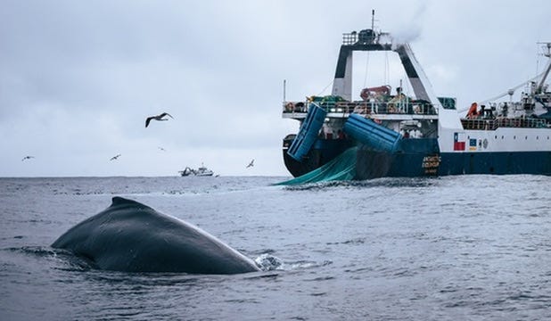
While the diplomatic community was marking this moment in New York, a Chinese factory ship, the Long Fa, was working the waters off the Antarctic Peninsula. Photographs taken by Sea Shepherd Global show it surrounded by humpback whales. The whales were there for the same reason the Long Fa was: krill. A crustacean barely five centimeters long, Euphausia superba is the pivot species of the entire Southern Ocean — the foundation on which the food web of whales, seals, and penguins rests. The Long Fa was fishing it commercially, at an industrial scale, for conversion into omega-3 dietary supplements and aquaculture feed.
This is the condition of ocean governance in early 2026: a landmark treaty in force, the world’s largest economy absent from it, and a factory ship surrounded by the animals whose food supply it is harvesting. The gap between these facts is not merely legal. It is a surveillance gap, an enforcement gap, and increasingly a political one — and it is being filled, imperfectly but ingeniously, not by governments but by a coalition of conservation organizations, satellite operators, and data scientists who have built, largely from scratch, the infrastructure to watch what states have declined to police.
Krill: The Pivot Species
Krill is not a charismatic animal. Euphausia superba is a shrimp-like crustacean, translucent, about the size of a human thumb, present in the Southern Ocean in numbers that beggar ordinary ecological description. Its estimated biomass — the total weight of all living krill — is in the region of 63 million metric tons, making it one of the most abundant animal species on earth. This abundance is not incidental. It is the structural condition on which the entire Southern Ocean food web depends.
Whales feed on krill. So do crabeater seals, whose name is a misnomer — they eat almost exclusively krill, strained through specialized teeth. So do Adélie and chinstrap penguins, and the great wandering albatrosses that quarter the Southern Ocean on wingspans of three meters. The humpbacks photographed around the Long Fa were not in those waters by accident. The Antarctic Peninsula, and the sub-area known to fisheries managers as Zone 48.1, is among the most productive krill habitats on earth, precisely the region where the factory fleet concentrates its operations.
That concentration is now occurring against a background of ecological stress unrelated to fishing. Krill require sea ice — specifically the algae that grow on its underside — for winter survival and reproduction. The Southern Ocean has experienced exceptional ice loss in recent years, and krill populations are already responding: their range is contracting poleward, compressing into the very waters where industrial trawling is heaviest. The fishing fleet and the climate crisis are, in this sense, working in the same direction. They are squeezing the population from opposite ends.
What is being extracted from these waters is not food in any meaningful sense. The krill harvest is destined overwhelmingly for fish oil capsules, aquaculture feed, and pet food — what one analyst has called a high-cost, high-impact supply chain serving a low-nutrition market. The whales need it to survive the Southern Ocean winter. The supplement industry needs it to meet quarterly sales targets in Oslo and Shanghai.
A Note on Krill
Euphausia superba is familiar by reputation — the food of whales, the foundation of the Southern Ocean food web — but the economic logic driving its industrial harvest is less well understood, and worth a moment’s attention.
Krill is not fished for direct human consumption in any significant quantity. What has driven the explosive growth in the harvest over the last decade is demand from three distinct industrial sectors, each with its own rationale. The first is the nutraceutical market. Krill oil has been aggressively marketed as a premium alternative to conventional fish oil, and the chemistry supports the distinction: the omega-3 fatty acids in krill are carried in phospholipids rather than triglycerides, which allows faster cellular absorption. Krill oil also contains astaxanthin, a naturally occurring antioxidant that gives the animal its red coloration and adds considerably to its appeal in a supplement market now worth over a billion dollars annually. The second driver is industrial aquaculture. Small quantities of krill meal added to farmed salmon feed act as an appetite stimulant — the animals eat more, grow faster, and develop the pink-orange flesh color that consumers expect. As global fish farming expands to meet protein demand, so does the appetite for krill as a feed additive. The third and most recently significant driver is premium pet food, where the same phospholipid omega-3 benefits being marketed to humans are now being marketed for aging dogs and cats.
None of this would necessarily be catastrophic if the fishing were distributed across the full range of krill habitat. It is not. The harvest is concentrated almost entirely in Zone 48.1, the waters of the Antarctic Peninsula — the same shallow, coastal feeding grounds where whales, penguins, and crabeater seals congregate. The danger is not to the global krill population, whose total biomass remains vast. The danger is local depletion in precisely the waters where depletion matters most.
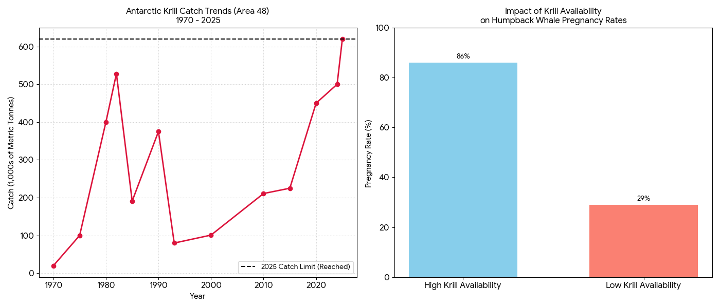
The consequences for whale populations are measurable and stark. A long-term study by the University of California, Santa Cruz, found that in years of high krill availability, up to 86 percent of sampled female humpback whales were pregnant. In years of low krill availability, that figure fell to 29 percent. The animals are not starving in any simple sense. They are being nutritionally stressed to the point where reproduction becomes physiologically unaffordable. Climate change is compounding the pressure independently: krill density around the Antarctic Peninsula has declined by an estimated 70 to 80 percent since the 1970s as sea ice — the nursery habitat for juvenile krill — has retreated.
There is a further dimension to this that conventional fisheries analysis tends to understate. When a whale consumes krill, it returns iron to the water column through excretion, fertilizing the phytoplankton on which krill themselves depend. The whale is not simply a predator in this system — it is a nutrient pump, cycling the building blocks of productivity back into the ecosystem. Industrial trawling removes krill from the system entirely, breaking that cycle permanently. The supertrawler extracts. The whale, if it can find enough to eat, recycles. These are not equivalent uses of the same resource.
The Body That Cannot Act
The CCAMLR (Commission for the Conservation of Antarctic Marine Living Resources) was established in 1982, under the Antarctic Treaty System, in direct response to concern about the impact of unregulated krill fishing on the Southern Ocean ecosystem. It is worth pausing on that date.
CCAMLR was created because the international community recognized, over four decades ago, that the Southern Ocean krill fishery required multilateral governance before the damage became irreversible. The Commission now has 26 member states. It operates by consensus. Any member can veto any measure.
In October 2024, China and Russia exercised that veto to block both the creation of new Marine Protected Areas across the Weddell Sea, East Antarctica, and the Antarctic Peninsula, and the renewal of the existing catch management measure that had allocated fishing effort across different zones of the fishery.
The practical consequence was immediate. Without the allocation measure, vessels were free to concentrate their effort wherever catches were highest, which meant Zone 48.1, the Antarctic Peninsula, the most ecologically sensitive and biologically productive area of the Southern Ocean. In the first seven months of the following season, the krill harvest reached 84 percent of the annual limit — hitting the fishery’s trigger level for the first time in its history, forcing an automatic early closure. Trawling activity in Zone 48.1 more than doubled compared to the entire previous season.
Norway simultaneously proposed raising the annual catch ceiling from 620,000 metric tons to nearly 1.2 million — a near doubling of the permitted harvest. That proposal was rejected by the majority of members, but its appearance on the table signals the direction of travel.
It is important to be precise about what China is doing here, because the imprecise version of the argument is both weaker and easier to dismiss. China’s krill fishing in the Southern Ocean is not, strictly speaking, illegal. It operates within CCAMLR’s framework, holds the required licenses, and reports its catches. The problem is not that China is breaking the rules. The problem is that China — with Russian support — is using its position inside the treaty body to prevent the rules from being strengthened, and to block the Marine Protected Areas that would constrain where the fleet can operate. This is a more sophisticated form of non-compliance than simple poaching, and considerably harder to counter. You cannot prosecute a veto.
Many will recognize the architecture of this problem. A multilateral treaty body, operating by consensus, in which the states with the greatest commercial or strategic interest in unrestricted access to a commons have both membership and veto rights, and are using those rights not to withdraw from the framework but to hollow it out from within. This is the dynamic that has entrapped CCAMLR. The treaty remains. The conservation it was designed to deliver does not.
Seeing in the Dark
In the absence of effective intergovernmental enforcement, a coalition of conservation organizations, satellite operators, and data scientists has built, largely from scratch, a system capable of monitoring the global fishing fleet with a level of comprehensiveness that no single government has achieved. Global Fishing Watch was founded in 2016 by three organizations: Oceana, a marine conservation group; SkyTruth, a nonprofit specializing in satellite imagery analysis; and Google, which contributed the cloud computing infrastructure without which the data volumes involved would be unmanageable. Its mandate is simple in principle and formidable in execution: to make human activity at sea common knowledge.
The foundation of the system is AIS — the Automatic Identification System, a GPS-based transponder technology that large commercial vessels are required by the International Maritime Organization to broadcast continuously, primarily to prevent collisions. Each year, more than 400,000 AIS devices broadcast vessel location, identity, course, and speed. Global Fishing Watch ingests this data continuously, and applies machine learning algorithms to distinguish fishing behavior from transit — the characteristic slowing, turning, and backtracking patterns that identify a vessel actively working its gear rather than moving between ports. The result is a real-time, openly accessible map of commercial fishing effort across the world’s oceans that simply did not exist before 2016.
The system’s more consequential capability, however, is what it can see when vessels don’t want to be seen. AIS can be switched off. Captains in contested or protected waters routinely do so, either to conceal their location from regulators or, in some cases, to falsify their position entirely — broadcasting coordinates placing them in open water while satellite radar imagery locates the vessel elsewhere. Global Fishing Watch calls these “dark vessels,” and they are disproportionately associated with illegal, unreported, and unregulated fishing. Of the vessels on the international IUU fishing blacklist, only a handful have consistently broadcast AIS.
To find them, Global Fishing Watch layers four satellite technologies simultaneously. Synthetic Aperture Radar — SAR — penetrates cloud cover and works in all weather conditions, day or night, producing imagery at a resolution sufficient to detect vessels over fifteen meters in length. The Visible Infrared Imaging Radiometer Suite, a NASA sensor aboard a polar-orbiting satellite, images the entire earth’s surface every twenty-four hours and is sensitive enough to detect the working lights of fishing vessels at night — the bright floodlights that squid vessels use to attract their catch to the surface, visible from orbit as a faint archipelago of moving points across otherwise dark ocean. Optical satellite imagery, where cloud cover permits, adds a further layer. All of this is continuously cross-referenced against the AIS record, with machine learning identifying gaps — vessels that appear on radar or in night imagery but are absent from the transponder data. Those are the dark vessels. Those are the ones that require explanation.
The results have redrawn the map of global fishing effort. Around the Galápagos, approximately thirty percent of the fleet operating in the adjacent high seas is running dark at any given time — present in the satellite record, absent from the public one. The system has revealed large, previously unmonitored fleets in the Indian Ocean, documented systematic AIS manipulation by vessels operating in the waters of multiple African nations, and identified the transshipment encounters — the at-sea transfers of catch from fishing vessels to refrigerated cargo ships — through which illegally caught fish enter the legitimate supply chain. A Chinese vessel caught inside the Galápagos Marine Reserve in 2017 with 300 tons of marine life, including 6,000 dead sharks, was visible to this kind of analysis. The question was always whether anyone was looking.
There is a deterrent effect, where the watching is known to be happening. At Costa Rica’s Cocos Island National Park, evidence of illegal fishing decreased substantially after satellite and radar tracking were made operational. Similar results are being recorded in the Galápagos. The technology is not a substitute for enforcement — a dark vessel identified is not a dark vessel stopped — but it removes the impunity that has historically made the high seas a low-risk environment for those willing to fish outside any legal framework. You cannot unsee what the satellites have seen. The question is what the seeing is worth when the political architecture required to act on it is in the condition described in the previous section.
The Line in the Water
The Galápagos Marine Reserve is one of the largest in the world, covering approximately 133,000 square kilometers of ocean around the archipelago. It was established in 1998, following decades of conservation advocacy that this series has traced elsewhere — the 1964 visit of the Royal Yacht Britannia, the influence of Prince Philip, Peter Scott, and Julian Huxley on the early institutional framework of what became the Charles Darwin Foundation, the slow construction of an international consensus that these islands and their surrounding waters constituted a natural patrimony requiring protection beyond the capacity of any single nation to provide. That architecture took forty years to build. It is now being tested by a different kind of pressure than its founders anticipated.
Each year, a fleet of several hundred Chinese distant-water fishing vessels positions itself in the international waters immediately adjacent to the Reserve boundary — legally, since they are outside the protected zone, but in numbers and with an intent that makes the boundary itself the operative fact. They are fishing primarily for squid, which migrate between the protected waters of the Reserve and the high seas beyond it, indifferent to the legal distinction. Global Fishing Watch has tracked this fleet continuously, and its night-light data — the VIIRS sensor detecting the squid vessels’ characteristic floodlights from orbit — reveals the full scale of an operation that AIS data alone would substantially undercount. Approximately thirty percent of the fleet is dark.
The 2017 incident remains the starkest illustration of what the boundary means in practice, and what its violation costs. A Chinese-flagged refrigerated cargo vessel, the Fu Yuan Yu Leng 999, was intercepted by the Ecuadorian navy inside the Reserve carrying 300 tons of marine life — 6,000 sharks among them, many of them protected species, finned and packed in the hold. The crew was prosecuted and sentenced. The vessel was visible in Global Fishing Watch’s retrospective analysis. It had been there before.
What has changed since 2017 is the sophistication of the surveillance. Global Fishing Watch has developed the first global database of transshipment encounters — the at-sea transfers through which fishing vessels offload their catch to refrigerated cargo ships without returning to port, allowing them to remain on the fishing grounds indefinitely and, critically, allowing illegally caught fish to be mixed with legal catch before it enters the supply chain. The transshipment database has already been used to identify vessels involved in moving illegally caught sharks through the Galápagos. The system can now see not only where vessels are fishing but how the catch moves from the point of extraction to the point of sale — the full logistics chain of industrial fishing made, for the first time, legible.
The deterrent effect is real, if incomplete. Illegal fishing activity around the Galápagos has decreased measurably since comprehensive satellite monitoring became operational. Ecuador, for its part, has expanded the Reserve boundary and increased naval patrol capacity, supported by international conservation funding. But the fleet outside the boundary has not diminished. It has, if anything, grown more sophisticated in its own right — better at managing AIS compliance at the boundary while exploiting the dark intervals beyond it, better at transshipment logistics, better at the legal ambiguities that the patchwork governance of the high seas continues to provide.
The line in the water is real. So is the pressure against it. What holds the line, at present, is a combination of Ecuadorian naval capacity, international conservation funding, and the continuous attention of satellites operated by a nonprofit organization founded a decade ago by a conservation group, a small technology nonprofit, and a search engine company. This is not, by any reasonable standard, a robust enforcement architecture. It is, however, what exists.
The Reckoning
The Southern Ocean is not only where the world’s largest animals come to feed. It is also where the planet keeps its records. The ice cores drilled from the Antarctic shelf contain the most complete archive of atmospheric history available to science — 800,000 years of temperature, greenhouse gas concentration, and climate variability, laid down in annual layers with a precision no human instrument can match. The ocean temperature gradients of the Southern Ocean drive the thermohaline circulation that distributes heat across the entire planet. The sea ice extent, measured season by season, is among the primary indicators that climate scientists use to track the acceleration of planetary warming. What is being disrupted in Zone 48.1 is not only a food web. It is the instrumentation of the earth itself.
The Rice whale — Balaenoptera ricei — was identified as a distinct species only in 2021. It lives exclusively in the Gulf of Mexico, numbers perhaps fifty individuals, and was the subject of an earlier dispatch in this series. Its situation illustrates with particular clarity what the collapse of ocean governance means in practice: a species so recently known to science that it had no name when most of its habitat was already compromised, threatened not by deliberate hunting but by the accumulated pressure of industrial activity conducted at a scale and in locations that no single regulatory body has the authority or the will to address. The krill trawlers working in Zone 48.1 are not targeting the Rice whale. They are simply removing, at an industrial scale, the foundation on which the food web that sustains it — and a hundred other species — depends. The mechanism is indirection. The consequence is the same.
Against this, what do we have? We have a nonprofit organization founded a decade ago that can now monitor every vessel on the planet's oceans, including the ones that don't want to be watched. We have a treaty that took 20 years to negotiate and entered into force in January, without the participation of the world's largest economy. We have a commission established in 1982 to prevent precisely what is now occurring, which cannot act because two of its members have calculated that their interests are better served by preventing action than by enabling it. And we have a coral cryobiologist at the Smithsonian, Mary Hagedorn, proposing that we send the cryopreserved genetic material of the earth's most endangered species to the permanently shadowed polar craters of the moon — where temperatures of minus 250 degrees Celsius would preserve them indefinitely without power or human intervention — because there is, she notes, no longer any place on earth cold enough to guarantee their safety. The Artemis program's planned infrastructure at the lunar south pole makes the logistics, if not yet the politics, conceivable. Ariadne hopes to have a full interview with Dr. Hagedorn later this year.
This is the condition we have reached: the surveillance is working, the governance is not, and the backup plan involves the moon.
The questions this raises — about the energy demands of the satellite and computing infrastructure on which all of this depends, about the AI data centers now consuming electricity at a rate that is itself accelerating the climate crisis that is driving the extinctions that the lunar biorepository is designed to hedge against — are not questions this dispatch can resolve. They are questions for future ones. What can be said here is that the technology being deployed to watch the oceans, to track the dark vessels, to model the krill population dynamics, and to cryopreserve the genetic heritage of a disappearing world is extraordinary. It is also insufficient. It has always been insufficient. The question Attenborough posed in 1979 — in whose hands does the future of all living creatures lie — has not changed. Only the urgency of the answer has.
© 2026 Farooq Hussain
How to lend a hand:
The organizations below are directly engaged in the issues this piece describes. Several are little known outside specialist circles despite doing work of considerable consequence. All accept donations.
Global Fishing Watch — the satellite surveillance system at the center of this piece. Openly accessible data, nonprofit, fundable directly.
globalfishingwatch.org
SkyTruth — the satellite imagery analysis nonprofit that co-founded Global Fishing Watch with Oceana and Google. Small, specialized, and largely unknown to the general public.
skytruth.org
Sea Shepherd Global — the direct-action conservation fleet whose photographers documented the Long Fa and Fu Xing Hai in Antarctic waters. Four-star Charity Navigator rating, 100% accountability score.
seashepherd.org
High Seas Alliance — the coalition that drove the BBNJ Agreement through twenty years of negotiations. Now focused on implementation and universal ratification.
highseasalliance.org
Pew Bertarelli Ocean Legacy Project — focused specifically on Antarctic Marine Protected Areas and CCAMLR governance.
pewtrusts.org/ocean-legacy
Antarctic and Southern Ocean Coalition — the principal NGO observer at CCAMLR meetings, directly engaged in the governance failures described here.
asoc.org
Oceana — the marine conservation organization that co-founded Global Fishing Watch and conducts independent analysis of Chinese distant-water fishing fleets.
oceana.org
Notes
Schlosser, Eric. Command and Control: Nuclear Weapons, the Damascus Accident, and the Illusion of Safety. Penguin Books, 2014.
Ellsberg, Daniel. The Doomsday Machine: Confessions of a Nuclear War Planner. Bloomsbury, 2017
Soaring human demand for krill in the Southern Ocean poses a challenge to the recovery of whale species once hunted nearly to extinction.
https://news.stanford.edu/stories/2024/09/krill-harvesting-threatens-whale-recovery
Excellent writing and sources for us to do our small part. Thank you.